Blaskets View – Wild Atlantic Way

Blaskets View
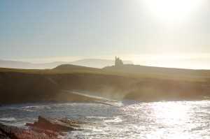
Blaskets View, or Radharc na mBlascaoidí, on the Wild Atlantic Way is another signature point that stands on its own merit as well as being part of the longest tourist trail in Ireland.

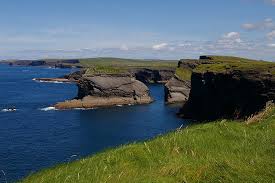
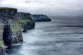
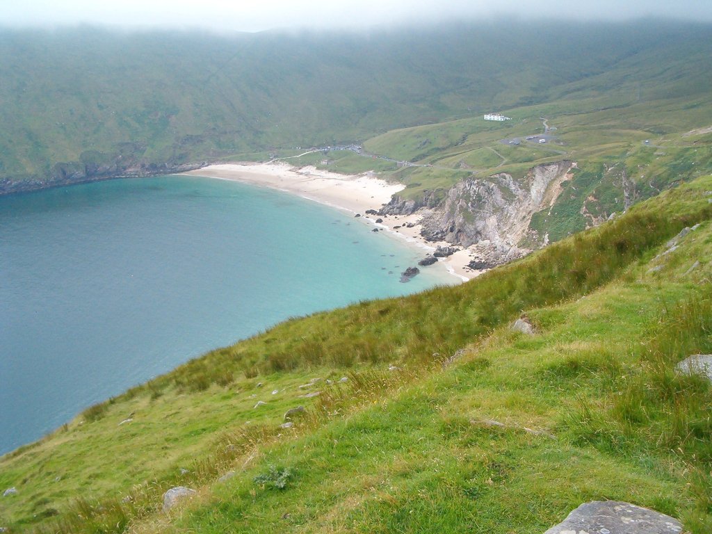
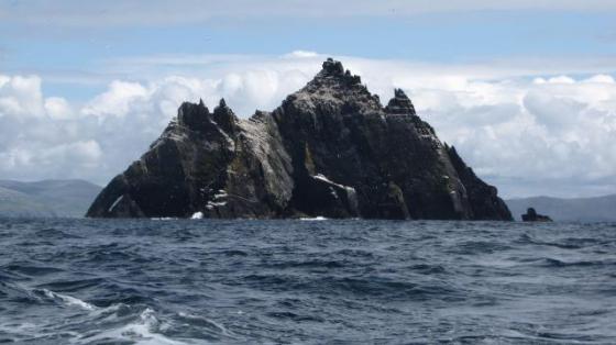
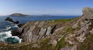
Officially known as the Blasket Islands, this signature point of the Wild Atlantic Way can be found at Dingle Peninsula, County Kerry. The islands are the most western part of Europe and the last stop until the North American continent to the west.

As the crow flies, the Blasket Islands are only 1km from land. However, the direct route is regarded as too dangerous to use, so a 5km loop is necessary to get there safely. It is believed that the islands were once part of the mainland and gradually separated over millions of years.

The largest of the islands, Great Blasket was inhabited until 1953. At its peak, there were 175 people living there. The earliest record, from 1593, has people living and working on the island and several records between then and now support fairly constant habitation.

The village was small and was home to very hardy folk who made their living from land and sea. There was no electricity, no running water and no modern comforts. As far as we can tell, the people only left the island once there were not enough strong men in the families to row the boats to the mainland.

The islanders were literary people, with over 40 books having been published by various residents. Some included the first written work of oral Gaelic histories and culture.

Modern visitors to the Blasket Islands can take in Blaskets View. Look west to the Americas like thousands before you and look all around to see dolphins, whales and seabirds by the hundred. It’s an eerie place that evokes contemplation but is well worth the visit.

Back on the mainland, you can then visit the Blasket Centre. The centre is dedicated to celebrating the life and history of the islands and the islanders and makes for a good stop on your tour.

The highlight has to be The Journey. A stained glass piece that uses 300 glass panels and weighs over 3 tons. There are also examples of the islanders literary accomplishments too that give an incredible insight to the life they led while still resident on Blaskets.

Blaskets View and the Blasket Islands are a poignant stop along the Wild Atlantic Way. Not only is the landscape and seascape dramatic, there is a real insight to a part of Irish life you wouldn’t normally be able to explore. For this alone, it’s a must-see while you’re here.

Mullaghmore Head – Wild Atlantic Way

Mullaghmore HeadMullaghmore Head in County Sligo is a very popular water sports and seaside destination as well as a stop on the Wild Atlantic Way.

Located in the north west of Ireland, between Grange and Bundoram along the N15, the promontory that makes up Mullaghmore is all about the sea. Set close to the borders of County Leitrim and Donegal, it’s an impressive setting with uninterrupted views of Benbulben Mountain, Donegal and Sligo Bay.

With 3km of lovely golden beaches, lots of rugged coastline, little bays, rocky outcroppings, coves and lovely clear water, it’s no wonder it’s a mecca for water sports enthusiasts.

The west coast of Ireland is an exceptionally popular destination for surfers and Bundoram is at the centre of that. The geography of Mullaghmore Head gives it the “prowler” a unique wave type that has been said to reach over 100ft up to several miles off the coast.

This brought Ireland it’s first Big Wave contest in 2011 which saw surfers from across the world compete here. Earlier this year, pro surfer Kirt Rist rode a 55ft prowler wave over a mile off the shore of Mullaghmore Head. If you love the surf, this is the place to be!

Mullaghmore also offers a range of other activities too, from fishing, scuba diving, snorkelling, boat trips and walks along the cliffs. Of course, being part of the Wild Atlantic Way means there are lots of paths and defined coastal walks for you to enjoy while you’re here.

The village of Mullaghmore itself was once owned by Lord Palmerston who was Master of the Rolls in Dublin. He was granted 12,000 acres of land in the area and built Classiebawn Castle on the peninsula. He also brought in immigrants from Liverpool to work the land and build a community. The village of Mullaghmore was created and a harbour built to service it.

Classiebawn Castle was passed down the generations until it was given to Lord Mountbatten before he was killed off the coast of Mullaghmore in 1979.

The village and harbour have prospered thanks to tourism and local industry. The harbour is still busy, local fare, arts and crafts are still sold locally and nationally too. It’s a typical Irish village that would be worth a visit even if it wasn’t part of the Wild Atlantic Way!

Loop Head – Wild Atlantic Way

Loop Head - Wild Atlantic WayLoop Head forms part of the Loop Head Peninsula in West Clare, Ireland. It also forms an integral part of the Wild Atlantic Way. Set on the west coast of County Clare along the Atlantic Coast, Loop Head offers some amazing scenery and stunning views.

Loop Head has been described as “a gnarled finger that juts into the Atlantic Ocean pointing westward.” It’s an accurate description. Set alongside the River Shannon and jutting out into the Atlantic Ocean, this little spit of land has more coastline than anywhere else in Ireland.

Loop Head is believed to be an evolution of “Leap Head” (Ceann Léime). Legend has it that a local, Cúchulainn jumped the gap between the headland and a sea stack to escape a local witch.

Another local legend says that two young lovers, Diarmuid and Gráinne leapt the stack to escape Fionn Mac Cumhaill. That’s why the stack is now called Diarmuid and Gráinne’s Rock. Whichever, if any, legend is true, it adds a bit of colour to the region!

Loop Head is also in the middle of the Wild Atlantic Way, meaning whichever way you travel it, Loop Head will always be the halfway point of your journey.

In 2010, Loop Head was awarded the title of European Destination of Excellence in aquatic tourism. This was a big boost to the area that reflected the true value of this mile-long piece of land.

It isn’t all about the scenery though. Loop Head is also working land. There are farms with lots of cattle around that have formed part of our local way of life. You will also find lots of homesteads, our local low buildings that provide warmth and comfort after a long day working on the land or at sea.

There’s a lot to see and do at Loop Head as there is along most parts of the Wild Atlantic Way. There is walking, cycling, fishing, the West Clare Railway, bird watching and of course, walking the Wild Atlantic Way itself.

One of the highlights of the area is Loop Head Lighthouse. It’s one of many successive lighthouses that have stood guard over the Shannon Estuary since 1670. The current lighthouse was built in 1854 and still lights the night sky for miles around. Tours are also conducted during summer.

It’s difficult to sum up the Loop Head part of the Wild Atlantic Way without repeating the superlatives we use to describe many of the other locations. The sheer beauty and drama of this coastal scenery simply defies description. That’s why you need to see it for yourself.

Visit holidaycottages.net for a range of high quality accommodation spread across Ireland and along the entire Wild Atlantic Way!

Cliffs of Moher – Wild Atlantic Way

Cliffs of Moher - Wild Atlantic WayThe Cliffs of Moher are one of the most visited natural phenomena in Ireland. Already part of a series of walks across Ireland, being added to the Wild Atlantic Way only adds to its appeal.

The Cliffs of Moher are located on the west coast of County Clare. They loom 214m over the Atlantic Ocean at their highest point and offer some truly amazing views out over the ocean and across the dramatic coastline of County Clare.

The trail that takes in the Cliffs of Moher is 8km in length. From the south of the trail and looking north, you can see Hag’s Head, a rocky promontory that resembles a seated woman.

Travel north and you’ll come across the Cliffs of Moher Visitor Experience, a modern visitors centre set into the hillside. The centre contains award-winning educational displays, interesting histories and everything you ever wanted to know about the region. Guides are also available for personal tours that are well worth booking in advance.

Along the Cliffs of Moher, slightly south of the visitor’s centre, you’ll come across O’Briens Tower, a 19th century construction originally designed for tourists. It was built in 1835 by a visionary who saw the potential of the area for visitors and those who would appreciate the spectacular scenery the cliffs provided. When the weather is agreeable, you can see all the way to the Galway Islands from it.

As part of the visitor centre, there are three platforms along the cliffs, the main, north and south platform. The main platform provides an exceptional view of the southern part of the Cliffs of Moher and Hag’s Head.

The north platform can be found at Knockardakin, the highest point of the cliffs. Standing 214m (700 feet) above sea level, next to O’Briens Tower it provides an amazing view the An Branán Mór Sea Stack and it’s collection of seabirds and Aill Na Searrach, the famous surfing wave when it’s here.

The south platform provides views to Goat Island where our local Puffin population live. You also get a different perspective of An Branán Mór Sea Stack and O’Briens Tower.

After taking in the wonders of the Cliffs of Moher, you can treat yourself to a well-earned coffee in the visitor’s centre while you compare notes and pictures. The Cliffs and indeed all of the Wild Atlantic Way offer more photographic opportunities than you could ever wish for. Ireland has to be one of the most photogenic countries in the world and for good reason!

Killary Harbour – Wild Atlantic Way

Killary HarbourKillary Harbour (An Caoláire Rua) forms part of the Wild Atlantic Way and sits comfortably between County Galway and County Mayo. Accessed from Connemara near the N59, the harbour is actually a fjord that separates the two counties. It’s another fascinating point of interest on the Way and well worth a visit.

Killary Harbour is 16km long and is one of three glacial fjords in Ireland. The scenery is of course, stunning. With wide expanses of green hills with mountains as a backdrop, it’s another natural wonder in an island full of them. Yet we never seem to get bored of seeing them as they all have something a little different to offer.

The sky is huge here. While there are mountains in the distance, the region is fairly low. Rolling meadows and low hills fill the parts of the horizon not dominated by mountains in a full 360 degrees. The harbour is deep, tranquil and lovely to behold. It’s a calm place, full of serenity and history and one we would never tire of enjoying.

On the way to Killary Harbour, you can see Croagh Patrick in the distance. It was here that St. Patrick fasted for 40 days and 40 nights so he could do penance and banish snakes from Ireland.

Back to Killary Harbour and the mountain backdrop changes to Mweelrea to the north, Connach’s tallest mountain and Maumturk Mountains and the Twelve Bens to the south. The settlements of Rossroe and Leenaun are nearby and are well worth a visit on your way to or from the harbour.

As well as walking along the fjord, you also have the option to have a guided tour by a local expert or to ride along on a Connemara pony. Either offers a unique opportunity to see the region from a different perspective and to immerse yourself in local culture. Pony riding is popular here and you will see many horses and ponies being ridden while you’re wandering around.

If you have an interest in history, the Green Road runs alongside Killary Harbour that you can walk along. This road formed part of the famine relief program in the 19th century, providing the means to get food inland during those harshest of times. It’s a 9km walk and is worth the time for the scenery alone, even if history isn’t to your taste.

The Killary Harbour part of the Wild Atlantic Way is most definitely Ireland, but could also be in Scandinavia. It’s a green land full of light, quiet and amazing scenery and it’s no wonder it was chosen as a signature point along the tour.

If you’re planning to travel Wild Atlantic Way, holidaycottages.net has a selection of high quality holiday cottages for you to use along the way. Perfect for your Irish adventure!

Keem Strand – Wild Atlantic Way

Keem StrandSet in County Donegal, Keem Strand is another signature discovery point along the Wild Atlantic Way. It’s one of three points that includes Mullaghmore Head and Downpatrick Head in a 625km part of the Way that make up one of the most interesting parts of this west coast route.

The Wild Atlantic Way is a new venture for Ireland and one that’s set to become an iconic route alongside Route 66 and Land’s End to John ‘o Groats. It’s a spectacular tour that can be done in a single trip or broken up into multiples and enjoyed over years.

Either way, holidaycottages.net has the perfect stopovers for your journey, however you’re doing it!

Keem Strand is set on Achill Island, one of Ireland’s biggest islands and one of its best kept secrets. It’s a secluded area that sits at the head of a valley between the Benmore cliffs and Croaghaun Mountain.

The horseshoe shaped bay contains a blue flag beach that is one of the most beautiful places in Ireland. The scenery is dramatic, the setting lovely, the bay peaceful and the entire region is devoid of the noise and clutter of modern life. It’s an ideal escape from the world and well worth a visit.

If you were to imagine your perfect beach location, we think Keem Strand would come close. Lovely golden sand, a calm, quiet bay, clear water, sunshine, a faint breeze and plenty of space to spread out and relax. It’s time away from the world and an opportunity to enjoy nature in all its beauty.

If you want a bit more action, there are water sports opportunities nearby along with surf schools and local amenities.

To get to Keem Strand, you head north to Golden Strand near Slievemore Mountain. There is an old settlement nearby called the Deserted Village which you can explore if you feel like it. If you would like to know more about the village, local archaeologists run guided tours at regular intervals. Either way, it’s a great way to spend a couple of hours.

Keem Strand is just one of many stops along the Wild Atlantic Way, yet it’s also one of the most alluring. The idea that somewhere so idyllic could be found within a couple of hours travel from where we live is surprising.

The quality of the landscape, the warm Irish welcome and the opportunity to see some of the most beautiful scenery to be found anywhere makes the Wild Atlantic Way a must-see for anyone who has ever wanted to visit Ireland.

If you need somewhere to stay while you’re here, holidaycottages.net can help. Use the search function on this page to find the perfect holiday cottage for your trip.

Old Head of Kinsale – Wild Atlantic Way

Old Head of KinsaleThe Old Head of Kinsale in County Cork is regarded by many as the official start of the Wild Atlantic Way. However, as you can begin or end your Way experience in either direction, it can also be considered the last point too. It forms the Kinsale to Clonakilty section which stretches for 92km.

Kinsale is a lovely seaside town on the coast in County Cork. It has lots of history in its buildings, Desmond Castle, Charles Fort and of course, having been the ground for the Battle of Kinsale in 1601. It is a fantastic place to begin or end your tour of the Wild Atlantic Way.

The town is friendly, welcoming and full of quaint shops, artisans, pubs and restaurants. There are also numerous fishing charters that run out of the harbour if you fancy trying your luck.

The Old Head of Kinsale is a coastal promontory that edges out into the Celtic Sea. On top sits a lighthouse with the traditional red and white horizontal stripes. It makes for an excellent landmark and is well worth a visit if you can get to it.

The lighthouse was built in the 17th century to one Robert Reading to warn shipping of the rocks. The RMS Lusitania was sunk by a German U-boat 11 miles offshore in 1915. It adds an element of gravitas and history to the point which only adds to the character. The sinking indirectly led to the United States entering the war on the side of the Allies.

A golf course has effectively blocked access to the Old Head of Kinsale from the land side, with fencing and a gate. However you can take a boat trip from Kinsale around the Old Head of Kinsale and see it that way. You can also enjoy the cliffs and take in the Old Head from a distance outside the course.

Clonakilty is another lovely seaside town with lovely coloured houses, a bustling centre, plenty of pubs and restaurants. It’s also the birthplace of Michael Collins, the person who was instrumental in making Ireland a republic. That fact is celebrated here almost everywhere.

Other highlights include the Drombeg Stone Circle, Galley Head Lighthouse and Timoleague Abbey. There are of course, lots of things to see and do in Clonakilty before leaving the town and making your way back to Kinsale.

It’s a shame you can’t get up close and personal with the Old Head of Kinsale, but the area it beautiful enough to make up for it. The trip between Kinsale and Clonakilty is a worthy beginning, or end, to the Wild Atlantic Way and we enjoyed every minute of it!

We feature a number of holiday cottages in and around County Cork. Just search from the box on the left to find something special!

Skellig Viewpoint – Wild Atlantic Way

Skellig ViewpointSkellig Viewpoint in County Kerry is an excellent opportunity to take in some of that amazing Atlantic coastline while also viewing the Skellig Islands. Skellig Viewpoint forms part of the Wild Atlantic Way in County Kerry and is rapidly becoming one of the highlights of the route. The islands have always been a local attraction with people coming from all around to watch the birds and to check out the archaeology.

There are three sandstone rocks that make up Skellig Islands but only two are named. Skellig Michael and Small Skellig stand proud against the battering of the Atlantic Ocean and are what draws so many visitors each year. Skellig Michael is the archaeological site, with an ancient monastery on it. Michael is a UNESCO World Heritage Site.

To support the site, the Skellig Experience Centre was built to tell the story about the islands and the monks that lived upon Michael. It also discusses the seabirds on Small Skellig and the lighthouse nearby too, offering a complete overview of this loveliest of regions.

Small Skellig is for the ornithologists. It plays host to the second largest colony of gannets in the world and the Ring of Kerry is never without a pair of binoculars or two watching what’s going on.

If you’re lucky and the weather is agreeable, boat trips run regularly out to the Skellig Islands from the mainland. It takes around 45 minutes to get there and you can climb the 600 steps from the dock to the monastery if you’re feeling energetic enough!

Your boat will likely also make a circuit of Small Skellig to take a look at the island and the birds on it. It’s a great way to get up close and personal with this Irish landmark and offers some amazing scenery to boot.

County Kerry has a lot to see and do in its own right too. It even has its own “Kerry Way” which is a 214km long path that loops around Killarney. Kerry Way forms part of the Wild Atlantic Way but is a walkable, self-contained section.

The Kerry Way passes through Glenbeigh, Caherciveen, Waterville, Sneem and Kenmare, each of which is worth a visit. It takes approximately nine days to complete if you don’t stop too long admiring the view, absorbing Irish culture and sampling the local produce!

The Wild Atlantic Way has been designed to take in some of the very best of Ireland and Skellig Viewpoint is certainly one of them. Add in the Kerry Way and you have a great excuse to stay even longer to enjoy everything Ireland has to offer.

If you’re looking for a quality holiday cottage, holidaycottages.net can help!

Downpatrick Head – Wild Atlantic Way

Downpatrick HeadContinuing along the Wild Atlantic Way route having visited Fanad Head, we move on to Downpatrick Head. Another part of an amazing coastline on the northern edge of Ireland.

Located a couple of miles north of Ballycastle village in County Mayo, Downpatrick Head is an impressive area of coastline that includes a lovely coastal walk as well as drive. Downpatrick Head itself is a rugged landscape that includes cliffs, a rock stack and thousands of wild birds.

Highlights includes the ruins of an ancient church, a holy well and a stone cross. All remnants of what was a church of St. Patrick. It is believed that St. Patrick himself founded this church, so plays an important role in local and national religion. You can often see pilgrims wandering around the ruins, walking in the footsteps of a saint.

There is a statue dedicated to St. Patrick in the grounds of the church. It was built in the 1980s to replace an original that had stood for decades before.

From Downpatrick Head itself, when the weather is agreeable, you can see the Staggs of Broadhaven. This is a small collection of islands beyond the solitary stack just off the coast. The big stack is called Dún Briste (broken fort) and stands hundreds of metres tall, holding out alone against the might of the Atlantic Ocean.

From a purely aesthetic perspective, the setting is amazing. The wild sea crashing against the solitary rock stack circled by seabirds all day long. From a geological perspective, you can see the layers and layers of rock from the various ages of the earth. If ever you wanted to see how the earth around you is formed, this is it.

Near Downpatrick Head is Céide Fields, a Stone Age field system and visitor centre. The location shows the old fields, ancient stone walls, settlements and tombs. All have remained in fantastic condition thanks to the peat soil in the area.

While not as old as Dún Briste, it shows how long this green and pleasant land has been home to humans and how we have constantly tried to mould the landscape to our own needs. It’s well worth a visit if you have the time.

Downpatrick Head is an amazing piece of landscape included within the Wild Atlantic Way. It’s dramatic, isolated, ancient and historic. It has something for everyone and plays an essential part of the whole that is the Way.

Remember, Holidaycottages.net has a huge selection of holiday cottages in the north of Ireland. Check them out if you're planning to walk the Way!

Join us next week as we visit Skellig Viewpoint!

Fanad Head – Wild Atlantic Way

Fanad Head LighthouseFanad Head on the Fanad Peninsula is our next stop while we traverse the Wild Atlantic Way. It is located between Lough Swilly and Mulroy Bay on the north coast of County Donegal in Ireland.

This section of the Way covers around 60km and has some of the most amazing coastal views imaginable. I think we’re going to be saying that a lot during our tour, so please bear with us!

The Fanad Head section begins in Letterkenny and heads north along Lough Swilly. The gradual incline takes in some of the lovely green countryside of County Donegal until you close to the coast and see Ballymastocker Bay. There are three amazing beaches in the bay and if the sun is shining is well worth a sit down to admire.

These beaches in Ballymastocker Bay have apparently been voted some of the most beautiful in the world. While we can’t comment on that claim, we find it easy to believe when the sun is out!

Head north to Fanad Head itself and you see the lighthouse. The Fanad Head lighthouse sits high on the dramatic cliffs looking north into the Atlantic Ocean. It’s an impressive sight that again, has apparently been voted the second most beautiful lighthouse in the world after the Lindau Lighthouse in Germany.

Whatever the truth of that claim, the absolute truth is that the lighthouse and the region is breathtaking. If you want to see Fanad Head from a different perspective, there are boat tours run by a charter company from Rathmullan. Well worth a try if you want to see the Head from the sea.

Heading west to the Rosguill Peninsula, you’re faced with some of the most rugged coastline of the Wild Atlantic Way. Follow the road further west and around the coast to Horn Head for a perfect example of nature at work and the awesome power of the sea as waves crash against the coast even on the calmest day. It’s something to be see and photographed extensively!

From here you can see the old signal tower and if it’s clear enough, Tory Island that lies 14km off the coast directly opposite.

The Fanad Head part of the Wild Atlantic Way offers spectacular scenery, amazing views, a glimpse of the raw power of nature and some of the best beaches anywhere in the world. For those reasons alone it’s well worth a visit. Holidaycottages.net has a wide range of holiday accommodation dotted along the Irish coast, so check out our listings for holiday cottages nearby!

Join us next time as we continue from Fanad Head to Downpatrick Head along the Wild Atlantic Way!